Encompassing over 500,000 acres, the North Cascades National Park is the largest of the three National Park Service (NPS) units that comprise the North Cascades National Park Complex in the north-central portion of the state of Washington. The complex manages three contiguous NPS units: the North Cascades National Park, Ross Lake National Recreation Area, and Lake Chelan National Recreation Area. The North Cascades National Park is named after the North Cascades Range; the most expansive glacial system in the contiguous U.S. The park has nearly 9,000 feet of vertical relief, from the low-laying western valleys at roughly 400 ft to the summit of Goode Mountain.
Where is the North Cascades National Park?
| State | Washington State, USA |
| Coordinates | 48°49′58″N 121°20′51″W |
| Counties | Whatcom Skagit Chelan |
| Nearest city | Mount Vernon |
| Access | Most visitors access the park from Washington State Route 20, which follows the Skagit River. |
Winter warning
During the winter, heavy snows and a high risk of avalanches make it difficult and risky to visit parts of the park, such as the western slopes. The Washington State Route 20 is closed during parts of the winter season.
Mountains
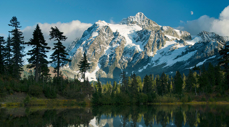
Erosion from water and glacial ice have made the mountains very steep. The tallest mountain in the park is the 9,200 ft (2,810 m) Goode Mountain, situated in the southern section of the park. This mountain requires some effort to to get to, as it is located far away from any road. Several other tall peaks are found in the same area, including Buckner Mountain(9,114 ft / 2,778 m) and Mount Logan (9,087 ft / 2,770 m). One of the most photographed mountains in the park is Mount Shuksan, since it looks very pretty as it towers over Baker Lake. In late summer, you can take the car fairly close, since the road to Artist Point is open. One of the tallest waterfalls in North American plunges off the southeastern flank of Mount Shuksan. In the northern part of the park, you’ll find Picket Range, which is a subrange of Skagit Range, which in turn is a subrange of the North Cascades. Picket Range is just 6 miles long, but contains 20+ peaks that exceeds 7,500 ft (2,300 m). Many Picket Range spires have rather discouraging names, such as Mount Terror, Mount Fury, Mount Challenger, Poltergeist Pinnacle, Ghost Peak, and Phantom Peak. Close to the Canadian border is the 2,737 m tall Mount Spickard and the just a few meters shorter Mount Redoubt.
Glaciers
There are over 300 glaciers within the national park; more than in any other U.S. park outside Alaska. Of all the glaciers in the lower 48 states, roughly one third are located within this specific national park. The largest glacier in the park is found on the northern slope of the Boston Peak. Other major glaciers are the East Nooksack and Sulphide glaciers on Mount Shuksan, the McAllister and Inspiration glaciers on Eldorado Peak, and the Redoubt glacier on Mount Redoubt. Melting water from glaciers is an important source of water for the streams and rivers in the park.
Lakes & Ponds
There are over 500 lakes and ponds in the North Cascades National Park. Many of these lakes are naturally fishless, since reaching them would require fish to move upwards through very steep terrain. As early as the 19th century, attempts were made to manually stock some of these lakes with fish – some more successful than others. Some lakes within the park look turquoise at times. This is because creeks and streams that empty into the them have brought with them finely ground rock particles from the glaciers (glacial flour) which give the water this appearance. The reservoir Diablo Lake is a good example of this. This beautiful turquoise lake is also a popular recreational spot for canoeing and kayaking, and provides a home for the threatened bull trout.