Mount Rainier National Park is located in southeast Pierce County and northeast Lewis County in Washington State. Established back in 1899, it is one of the oldest national parks in the whole country.
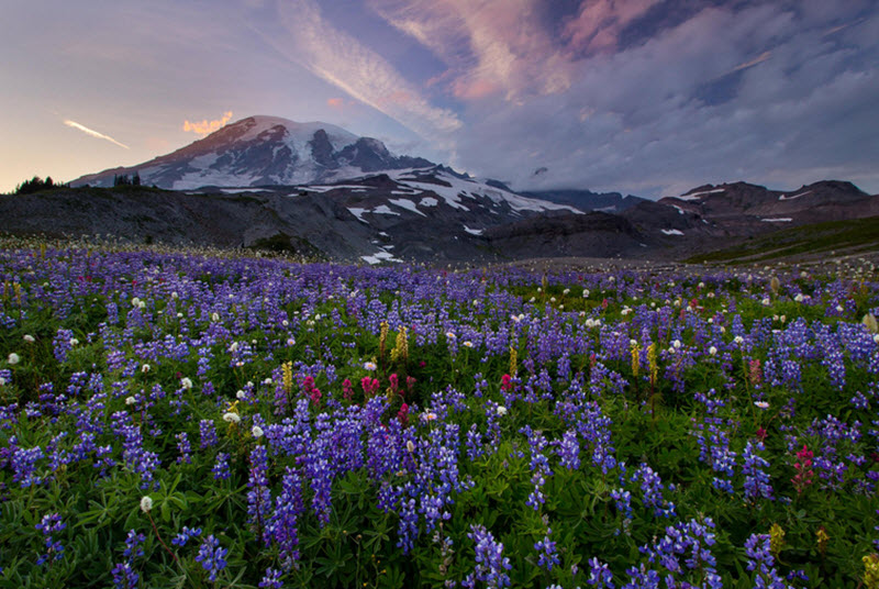
The park is named after Mount Rainier, a 4,302 meter tall stratovolcano that rises sharply from the surrounding land. This is the highest peak in the whole Cascade Range, and it is often shrouded in clouds. It’s a popular challenge for mountain climbers, with an estimated 10,000 attempts being made each year, out of which roughly 5,000 make it all the way up to the summit.
Examples of nature types and features that you can visit in the park are old-growth forest, subalpine meadows, waterfalls, snowfields, and more than two dozen glaciers. The Carbon glacier is the largest glacier by volume in the lower 48 states, while Emmons glacier is the largest by area.
Where is the Mount Rainier National Park?
| State | Washington State, USA |
| Coordinates | 46°51′N 121°45′W |
| Counties | Pierce County
Lewis County |
| Nearest city | Tacoma |
Snow
Paradise – a spot within the park at an elevation of 5,400 ft / 1,600 m – is one of the snowiest places on Earth where snowfall is measured regularly. Located on the southern slope of Mount Rainier, Paradise holds the Cascade Range record for most snow on the ground with 367 inches / 932 cm on 10 March 1956.
Animals
The park is home to a rich and varied fauna. Examples of mammals that live here are black bear, cougar, bobcat, coyote, red fox, marten, snowshoe hare, raccoon, beaver, snowshoe hare, mountain goat, and elk. Many birds can be spotted here too, including peregrine falcons, bald eagles, golden eagles, chikadees, kinglets, spotted owls, and ptarmigans.
Carbon glacier
The Carbon glacier is:
- The largest glacier by volume (0.2 cubic miles / 0.83 cubic km) in the lower 48 states.
- The longest glacier (5.7 miles / 0.2 km) in the lower 48 states.
- The thickest glacier (700 ft / 210 m) in the lower 48 states.
- The lowest-elevation glacier in the lower 48 states. The snout at the glacier terminal moraine is located just 3,500 ft / 1,100 m above sea level.
- The source of the Carbon River.
Located on the northern slope of Mount Rainier, this glacier is typically accessed through the northwest Carbon River entrance of the park, not far from the town Carbonado. From the park entrance, you need to hike for roughly 8 miles (13 km) to reach the glacier.
Emmons Glacier
While the Carbon glacier is the largest glacier by volume in the lower 48 states, Emmons glacier is the largest by surface area, measuring approximately 4.3 square miles / 11 square kilometers.
Emmons glacier is often used as a route by climbers looking to reach the Mount Rainier summit. The highest part of the glacier is located above 13,800 ft / 4,200 meters.
The glacier flows down in an eastward direction, and is eventually joined by the Ingraham glacier at 12,200 ft / 3,700 m. The two glaciers then accompany each other until the split at Little Tahoma Peak where Emmons turn northeast.
Camp Muir
Camp Muir is a high-altitude refuge for climbers on Mount Rainier. Located at 10,188 ft / 3,105 m, this is the most-used base camp for climbers attempting to reach the summit of Mount Rainier.
- The smaller shelter is a guide shelter built in 1916. It measures roughly 10 feet by 24 feet (3 x 7.3 m). This is the oldest stone structure in the whole park.
- The larger shelter was built in 1921. Its a 12-foot by 25-foot (3.7 x 7.6 m) single-story one-room shelter.
- Two stone pit toilets were built at Camp Muir in 1936. One of them has survived into our time, but it is only used as storage space.
Where is it?
Coordinates: 46°50′8″N121°43′53″W
Location: Between the Muir Snowfield and the Cowlitz Glacier on Mount Rainier
Access: Through the Paradise Entrance